
The National Hurricane Center has issued a tropical storm warning for St. Johns and Duval counties and much of the Sunshine State’s Atlantic Coast, in anticipation of Hurricane Idalia. St. Johns County Emergency Management is monitoring the storm and will provide updates as they are made available.
A tropical storm warning means tropical storm conditions (sustained winds of 39 to 73 mph) are expected within the affected area within 36 hours.
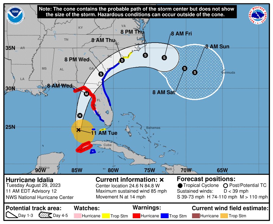
Idalia is expected to become a major hurricane by Wednesday morning, Aug. 30, as it nears the Gulf Coast of Florida. Much of Florida’s Gulf Coast has been under a hurricane warning.
At 11 a.m. local time on Tuesday, Aug. 29, the storm was located at 24.6 N 84.8 W. Its maximum sustained wind speed was 85 mph, and it was moving north at 14 mph.
Hurricane-force wind speed is between 74 and 110 mph. Major hurricane wind speed is greater than 110 mph.
This site may not maintain the latest information. For important information on being prepared or for local updates, go to www.sjcfl.us/hurricane.
Sign up for the Alert St. Johns emergency notification system at www.sjcemergencymanagement.com.
Register for Nixle Alerts by texting StJohnsEOC to 888777.
Call the St. Johns County Emergency Management Citizen Information Line at 904-824-5550 with any storm-related questions.
For information on Tuesday’s evacuation order, click HERE.
For information on free sandbags, click HERE.
For a list of closures and other announcements, click HERE.
Hurricane Franklin, a major hurricane with maximum sustained winds of 130 mph, is well offshore at 30.8 N 70.4 W and is expected to continue moving northeast, posing no threat to land.


