
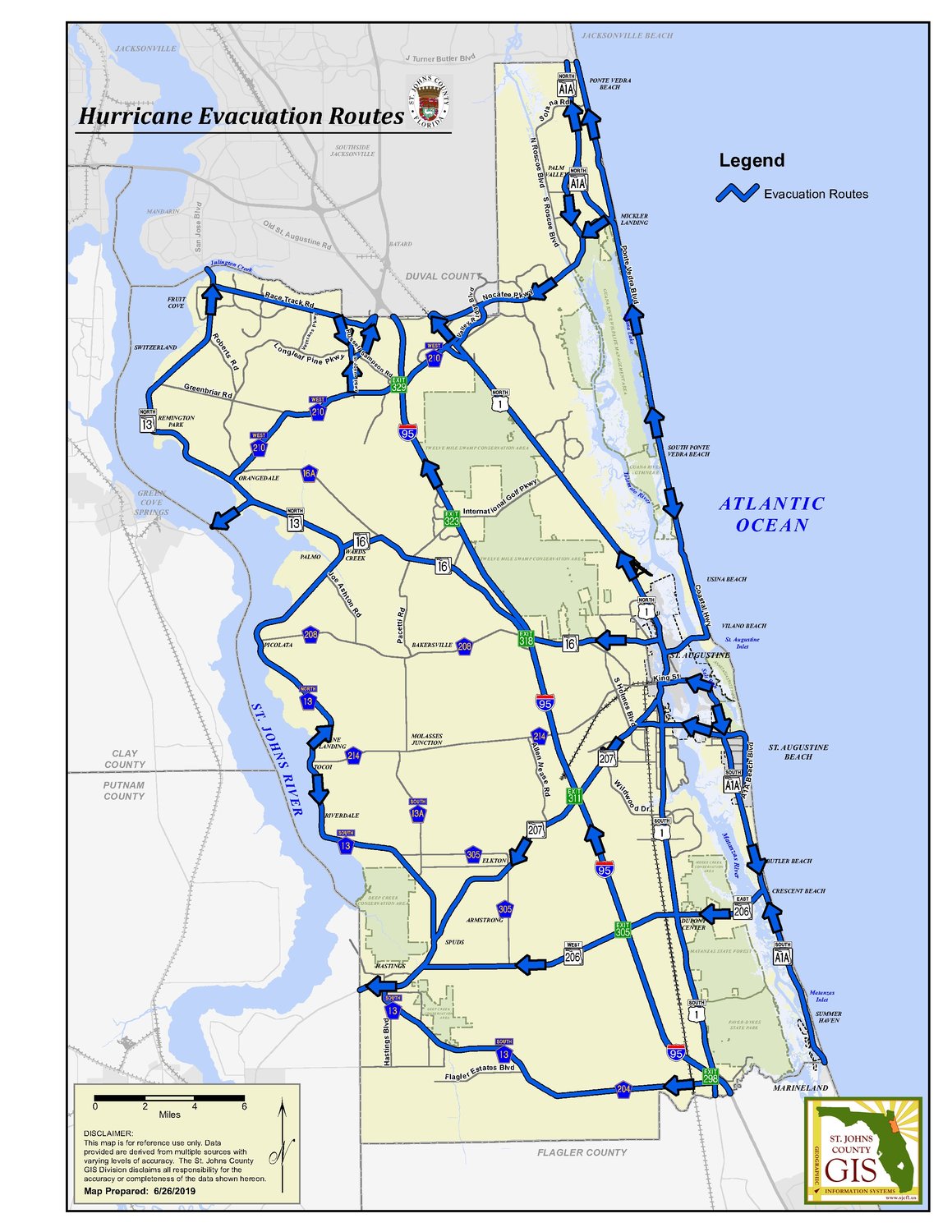


St. Johns County Emergency Management’s official website provides emergency evacuation routes, maps and preparation tips for all its residents.
Evacuation routes throughout St. Johns County are below:
City of St. Augustine: (On the mainland)
North on US-1, turn West onto SR-16 or proceed South-West on SR-207 or South on US-1, proceed to I-95 or points West.
City of St. Augustine: (Davis Shores, Anastasia Island South to St. Augustine Alligator Farm)
SR-A1A, proceed West across Bridge of Lions, to US-1 North or US-1 South and / or to SR-16, or SR-207 to I-95 or points West.
City of St. Augustine and Anastasia Island North of the St. Augustine Amphitheater:
Proceed North on SR-A1A across the Bridge of Lions, then West.
City of St. Augustine and Anastasia Island South of the St. Augustine Amphitheater:
Proceed South on SR-A1A, turn West on SR-312, proceed across 312 Bridge to SR-207, proceed to I-95 or points West.
City of St. Augustine Beach:
North to SR-312, proceed across 312 Bridge to SR-207, proceed to I-95 or points West.
From the intersection of Ocean Trace Rd. and A1A to Crescent Beach
South on SR-A1A to Crescent Beach, turn West on SR-206, proceed across Crescent Beach Bridge to US-1, proceed to I-95 or points West.
Crescent Beach to Flagler County Line:
North on SR-A1A to Crescent Beach, turn West on SR-206, proceed across Crescent Beach Bridge to US-1, proceed to I-95 or points West.
Palm Valley / Nocatee area:
Proceed South-West to CR-210, proceed to I-95 or points West.
Ponte Vedra Beach / Sawgrass:
North on SR-A1A, turn West onto Butler Blvd., proceed to I-95 or points West.
On coast halfway between Micklers Landing & South Ponte Vedra Beach
North of Guana Dam, go North to SR-A1A, proceed West across Palm Valley Bridge on CR-210. South of Guana Dam, go South on SR-A1A, proceed West across Vilano Bridge. Continue West on SR-16 to I-95 or points West.
SR-13 North of CR-210
Proceed East along CR-210 or Greenbriar Road to I-95; or North along SR-13 into Duval County; or east on Racetrack Road to areas outside the evacuation zone.
SR-13 North of CR-214
Proceed East along CR-208 or SR-16 to I-95; or West along SR-16 across the Shands Bridge; or East on CR-214 to areas outside the evacuation zone.
CR-13 South of CR-214
Proceed East along SR-207 or SR-206 to I-95; or West along SR-207 into Putnam County; or east on CR-214 to areas outside the evacuation zone.
For more information, visit www.sjcemergencymanagement.com/evacinfo.html
