

Forecasters with the National Weather Service are predicting above-normal hurricane activity in the Atlantic this year, but what that will mean for residents of the First Coast is anyone’s guess. Regardless of the number of named storms appearing in any given season, it only takes one to make a mess of things if it lands here.
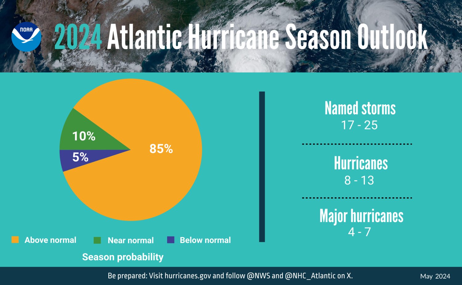
The forecasters, associated with NOAA’s Climate Prediction Center, predict an 85% chance of an above-normal season and a 10% chance of a near-normal season.
With 70% confidence, NOAA is predicting between 17 and 25 named storms with winds of at least 39 mph, between eight and 13 hurricanes with winds of at least 74 mph and between four and seven major hurricanes with winds of 111 mph or higher. Of course, with only 21 names reserved for this season, that means they may run out. That’s what happened in 2020, when there were 27 named storms, and officials began designating them by Greek numerals, the last being Hurricane Zeta.
NOAA’s 2024 forecast differs slightly from that of researchers at Colorado State University, which predicts 23 named storms, 11 of which are hurricanes and five major hurricanes. That’s higher than the averages for 1991 through 2020, which are 14.4 named storms, 7.2 hurricanes and 3.2 major hurricanes.
NOAA researchers base their forecasts on a confluence of several factors. La Nina conditions developing in the Pacific tend to reduce wind shear in the tropics, and a reduction in Atlantic trade winds also means less wind shear. Near-record high ocean temperatures generate more energy to fuel the development of storms. Also, a potential for above-normal monsoon activity in West Africa may produce more waves to seed strong Atlantic storms.
Meanwhile, the National Hurricane Center (NHC) has been making system upgrades and is planning improvements to forecast communications, decision support and storm recovery efforts.
On Aug. 15, it will launch an experimental version of its forecast cone graphic. It will depict inland tropical storm and hurricane watches and warnings. This is expected to help communicate inland hazards. The public can track storms and see maps of anticipated effects by going to nhc.noaa.gov.
Also, in past years, the NHC has issued updated advisories every six hours, with changes to the map at those intervals. Starting this year, it will be able to issue intermediate public advisories as condition changes demand.
The new Modular Ocean Model will better represent the role the ocean plays in driving storm intensity. Another model will focus on the chances of tropical cyclone rapid intensification.
A new generation of Flood Inundation Mapping will provide information to emergency and water managers to better allow them to respond to possible flooding and help local officials make preparations.
NOAA’s National Data Buoy Center has upgraded coastal weather buoys and NOAA will deploy uncrewed surface vehicles to provide better data. This month, dozens of observational underwater gliders will be deployed as well to collect data.


